Detailed description

Leaflet | © OpenStreetMap
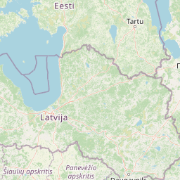
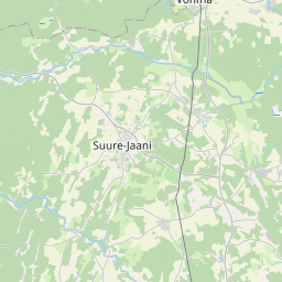
25.48 58.49, 25.82 58.58
Identity Description
| Title | [Char]te No 4. [von dem im Rigischen Gouver]nement Pernauschen Kreise und [Gross St. Johannischen K]irchspiel belegenen zum publiquen [Gute Weibstfer gehörigen] Streu Dorfe Oennisto |
|---|---|
| Map type | Single sheet map |
| Reference code | EAA.2072.3.4c sheet 2 |
Creators
| Firstname | Lastname | Occupation of cartographer | Creators position |
|---|---|---|---|
| Stellando de | Capaccio | kroonumaamõõtja | cartographer |
Cartographical and Publishing Description
| Main subject | Not set |
|---|---|
| Material designaton | plan |
| Manuscript/Printed | manuscript original |
| Certified by | Liivi-, Eesti- ja Kuramaa kindralkuberner, 04.02.1837 |
| Created | 19. saj I pool |
Components and Mathematical Description
| Components | explication, legend for symbols, compass, graphical scale |
|---|---|
| Azimuth | Not set |
| Textual scale | Maasstaab von 1300 Ellen = 15,3 cm, gleich einer viertel Elle livländische Feld-Maas |
| Relative scale | 5200 |
Geographical Description
| Admin unit | Specification |
|---|---|
| Estonia (to 1917) / Livonia Guberniya / Viljandi County / Suure Jaani Parish / Reegoldi Manor | Punistso |
Physical Description
| Storage form | rolled |
|---|---|
| Material and mounting | paper |
| Medium | ink+coloured |
| Dimensions (cm) | 41x81/A1 |
| Access-restrictions | No access restriction |